
Make the editor terrain tool shape more smooth
Bug #771838 reported by
Nicolai Hähnle
This bug affects 2 people
| Affects | Status | Importance | Assigned to | Milestone | |
|---|---|---|---|---|---|
| widelands |
Won't Fix
|
Wishlist
|
Unassigned | ||
Bug Description
The terrain tool in the editor (the tools used to set the terrain type such as water, mountain, grass, etc.) tends to create very jagged terrains, and it is tedious and takes a lot of practice to create smooth coast lines and other smooth features at all "natural" angles.
Proposed future behaviour:
1. At the smallest tool size, the terrain tool affects a single triangle of the terrain.
2. At all larger tool sizes, the terrain tool affects a perfectly hexagonal area centred at the Field that the mouse currently points at. In particular, at the second smallest tool size, the tool will affect precisely the six triangles that are incident to the Field that the user points at.

| Changed in widelands: | |
| status: | Opinion → Confirmed |
| importance: | Undecided → Wishlist |
| Changed in widelands: | |
| status: | Expired → Confirmed |
| Changed in widelands: | |
| status: | Expired → Confirmed |
| tags: |
added: world removed: terrain |
To post a comment you must log in.
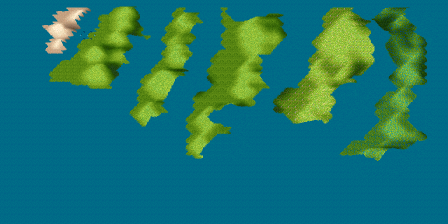
I am very much in favor of this suggestion,
but I am unsure whether this change alone
can explain the obvious differences in coastline shaping
that we can see comparing the WL to the S2 editor.
To further demonstrate the differences, I have prepared
a sample from the S2 editor that I attach here.
Please notice, how it is possible in the S2 editor to
form convex and concave borders (depending on
which terrain type you paint first).
I don't know how this is done, but the effect is more
pleasing than the straight tile characteric in the WL editor.
Please also note, how the water level is unaffected
by altitude changes.
(the WL editor requires tedious work for this and
sometimes cannot deliver convincing results.)
Mapmakers would probably like this feature.
On a sidenote I think that WL Editor either does a
stronger smoothing of the altitude profile, prohibiting
abrupt changes, or else uses a shading that
gives the impression of less altitude change.
Compared to its WL counterpart, the S2 Editor
seems to allow steeper mountains and valleys.