Custom unit
| Affects | Status | Importance | Assigned to | Milestone | |
|---|---|---|---|---|---|
| Inkscape |
New
|
Wishlist
|
Unassigned | ||
Bug Description
Hi.
I have a feature request.
I've found Inkscape very useful whan I have a map as a bitmap file and want to draw imaginal houses and roads on it. The maps have this scale symbol (100m may be equal to 30px on the image file).
So everytime I want to draw something on the map, I have to manually calculates the length on it before I actually draw it.
Therefore, a custom unit would have done map drawing a lot more easy to acomplish.
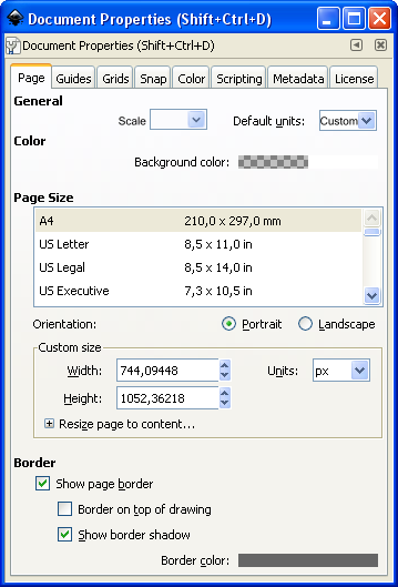
There could be a spinbox in Document Properties --> Page, next left of the text "Default Units".
The number in the spinbox should represent: Real world length / length of map scale symbol in pixels
An example:
A map file (PNG from Google maps) is exported into Inkscape. The scale symbol measure 34 pixels and represent one km in the real world. The custom unit would therefore be 1000m / 34px = 29,4117647.
I've atached how I imagine the placement of a new spin box in Document Properties. It should only be visible when Custom unit is choosen.

| tags: | added: preferences |
| Changed in inkscape: | |
| importance: | Undecided → Wishlist |
This feature would also be helpful in my case. I need a 3/32" grid, which is 0.09375", but inkscape only allows inputting 4 numbers after the decimal point.
The closest grid I can create is 3/16" (0.1875), but with this grid I need to place vertices at the midpoints of grid cells, which is impossible. If I could only create a grid where 1 units = 0.1875", I could create a grid with even 3/256" cells!